


Table of Contents
About the Community
Playa Blanca is a Mediterranean-style oceanfront community located between Rosarito and Tijuana. Playa Blanca, with only 84 condominiums, is a very low-density community considering the size of the property, which has 300 linear meters of sandy beach and surf out in front.
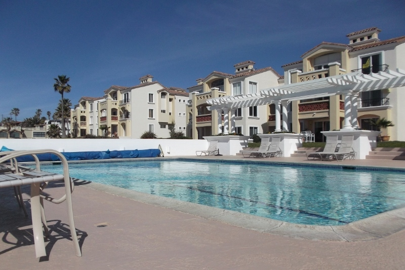
Also, Playa Blanca’s buildings are just 3 stories tall, and the parking areas are designed so that the front door to your home is never more than 1 floor away from your parking lot. When you compare Playa Blanca’s design and amenities with other Baja real estate alternatives, you will clearly see the advantages of this oceanfront community.
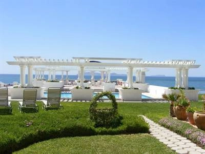
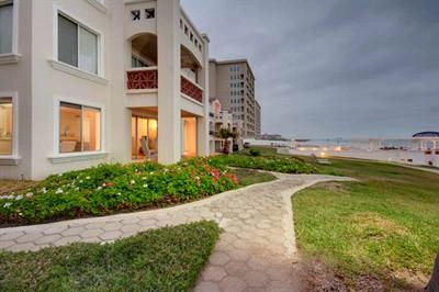
First, Playa Blanca is filled with amenities. There is a heated oceanfront swimming pool, oceanfront gym, oceanfront clubhouse, gardened walkways, large grassy areas, 24 hour security, on site HOA management, and plenty of parking. In addition to these man-made amenities, there are also key natural amenities at Playa Blanca.
First, Playa Blanca has an unobstructed view of the Pacific Ocean and the Coronado Islands, one of the most sought-after views in Baja and California.
Next, there is the sand beach that is miles long right in front of Playa Blanca. This is not a seasonal sand beach either. Playa Blanca’s sand beach is year round, both winter and summer.
Finally, Playa Blanca’s beach is an extremely good surfing beach. In fact, it is the most photographed Baja location by many surfing publications. Since it is a sand bottom surfing beach, it is also great for beginning surfers and bodyboarders.
The condominiums at Playa Blanca are 1 or 2 bedrooms, with the larger units close to 1200 square feet. They are all single level and are equipped with wood burning fireplaces, dishwashers, garbage disposals, washer and dryer, and central heating.
All units have high-speed internet available, and many television options, including U.S. based and Mexico based television stations. The upstairs condos have the advantages of tall vaulted ceilings. Playa Blanca’s buildings are all pastel, and the whole community affords ocean views, large open spaces, patios, and large grass areas.
Another Playa Blanca feature is its location. It has its own highway ramp and is just 15 minutes south of the border. Within two miles of Playa Blanca are a host of convenience stores, bakeries, pizzerias, family style restaurants, and cantinas.
Also within this 2-mile radius is the Real del Mar golf course, the tennis club, equestrian center, and Reina Isabel, one of the most renowned schools in Baja. Just south of Playa Blanca in Rosarito are huge supermarkets, plenty of local shops, the cinema for the latest movies, and a lot of great taco shops.
Amenities
- 84 villa style condos
- Year-round sandy beach
- 300 linear meters of oceanfront property
- All condos are single level
- Buildings are no more than 3 stories high
- Large heated oceanfront pool
- Oceanfront Jacuzzi
- Oceanfront gym
- Oceanfront clubhouse
- Sauna
- Washer and dryer (in most units)
- Dishwasher
- Garbage disposal
- Secured parking
- 24 Hour security and guarded gate
- Has its own off-ramp from the highway
- Pet-free environment
- On-site HOA
Driving Directions
To get to Playa Blanca from San Diego, cross the international border at the San Ysidro crossing. About half a mile past the border you will drive onto a bridge/overpass. Look for the signs and ramp on the right-hand side that lead you to Ensenada via Cuota. This ramp will come up quickly, so make sure you slow down and get yourself over to the right.
The Cuota is the toll road, also called the Scenic Road, or Escenica. Keep this in mind because you want to stay on the toll road to get to Playa Blanca and to the rest of Rosarito.
Over the next couple of miles, you will drive along the international border fence heading west. There can be construction at any time, but you just need to follow the signs for Ensenada, Rosarito, and Playas de Tijuana.
About 10 minutes from the border you will see signs for Playas de Tijuana. This means you are on the right track. However, when you come to the actual exit for Playas de Tijuana, do not exit. Stay left to continue on the toll road. You will come to a toll booth in which you will pay about $2.50 U.S. dollars. If you pay in dollars, they will give change in dollars.
After paying the toll, you will drive about 8 minutes more to arrive at Playa Blanca. Stay on the toll road until you see a bridge crossing the toll road. As soon as you go under this bridge, Playa Blanca is the next exit on the right-hand side of the road, the west or beachside.
Pull up to the guard gate. You will need an appointment with someone in Playa Blanca to be allowed inside Playa Blanca.
View Playa Blanca Map
On the Playa Blanca Listing page you will find what is currently on the market for sale and for rent.
For a great visual introduction to Playa Blanca, visit the Playa Blanca virtual tour page.